SHT 00/ 08
Know which roof needs a re-coat before the tenant calls.
One VHR pass over your portfolio each year. Roof, lot and yard condition scored per site and ranked, so the capex forecast is planned instead of triaged.
- GSD
- ≤0.3 m (VHR)
- Cadence
- Annual
- Platform
- VHR satellite / aerial
- Spectral
- RGB
- A Ponding stain
- B Patched seam
- C Cracked lot corner
How the capex forecast gets its condition notes
A consultant or an in-house engineer walks sites on a rotation, and what they find goes into a property condition assessment or the reserve study. Between visits the notes sit in the asset register or a capex spreadsheet, one line per site, carried forward year after year. Nobody walks every address every year. So when the asset committee sits down with the forecast, part of the portfolio is going in on notes from a visit several budget cycles back, and nobody can say whether that roof held up or has been quietly ponding since.
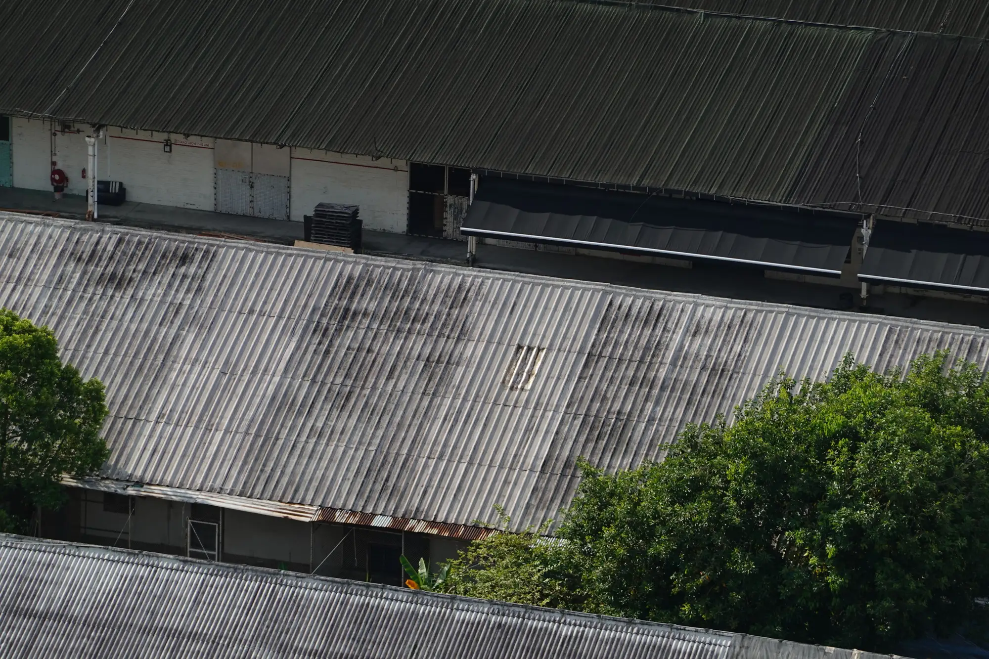
The sites that do get attention are the ones somebody called about. A property manager forwards a leak photo, a tenant complains about the lot, and the inspection rotation bends toward the squeaky wheel. The quiet site with a worn membrane and a cracked lot corner waits until the repair is an emergency instead of a planned line.
One annual pass scores every address the imagery can see and ranks them worst-first, so the walked visits go where the surface is worst and the forecast stops depending on whoever last complained.
What comes back
One delivery per annual pass, in files your capital plan already opens. On a pilot it covers the sites you pick.
2.1Condition score per siteRanked list
Each address gets a condition score for roof, lot and yard, ranked worst-first. It is a CSV that pastes into the capex forecast worksheet, keyed to your own site IDs.
2.2Flagged findingsLocation markers
Ponding, cracking, membrane wear and overgrowth, marked on the site with a location so the person who visits knows where to look first. Each flag says what was seen and on which part of the site.
2.3Portfolio map layerGeoPackage
Every address with its current condition class, exportable. It opens in ArcGIS or QGIS, and the asset committee gets a portfolio-wide view in place of whichever site last complained.
2.4Low-confidence flagsReview list
Sites with heavy shade, snow, or no clear image get a flag and a reason, and go on the walked list as they do today.
How it works
Sites in
Send your addresses or a boundary file, with your own site IDs. Mark which sites are in the pilot.
Imagery
We pick the latest clear VHR satellite or aerial pass over each site at 0.3 m or finer.
Analysis
Each roof, lot and yard is classified for condition. Anything the imagery can't see clearly is flagged instead of scored.
Delivery
The ranked list and the map layer, plus the review list. We set the delivery against your forecast calendar at the start and walk you through the top of the list on a call.
Before the reserve study
Where it fits in your workflow
It feeds the capex cycle and doesn't replace it. It sits before the reserve study, narrows which sites get a physical inspection this year, and gives the asset committee a view of every address. Your consultant still walks the top of the list, calls the scope, and signs the report. The roofing and paving bids come from that visit, not from us.
If you run a preventive program rather than worst-first, read the list from the other end. Sites in the middle bands are where a re-coat or a striping refresh still buys time.
Limits
L1Triage, not an inspection
This does not replace a roof inspector, an engineer or a code compliance review. The scores sort the list. They are not a certified condition rating, a Roof Condition Index from a field inspection or a PCI score.
L2Resolution floor
At 0.3 m a pixel is wider than a hairline crack. Single cracks are not traced; cracking shows as a broken-up surface across the lot, so early low-severity cracking can be missed. Roof findings are surface staining, patches and worn areas, never what is under the membrane.
L3Shade, snow, cloud
Optical imagery needs daylight and a clear sky. Trees and building shadow hide parts of a lot or roof, and snow hides the surface entirely. Those sites are flagged, never scored on a guess.
L4Tasking and timing
A fresh pass depends on satellite or aerial availability over your sites. It is not on demand within hours, and a cloudy season can push the pass later.
L5Once a year
One pass a year. A roof that fails in March shows up in next year's pass. Year one has no trend to show, and this is not continuous monitoring.
Who it's for
For
- Capital planning leads at a REIT or facilities management firm who build the capex forecast across many addresses
- Portfolio engineering teams deciding which sites to walk first this year
- Asset committees that want every address on one map, not only the ones that called
Not for
- A single building owner who wants a roof inspection report
- A team that requires a certified condition rating, a leak survey or a code compliance review
- Interior, structural or mechanical condition, which overhead imagery cannot see
- A team that requires weekly or real-time updates
Questions before a pilot
Can it replace a roof inspector?
No. It ranks which roofs need one. The sites at the top of the list still get walked before any work is bid.
How do we check it against our own notes?
Pick a few sites your consultant walked recently and keep those notes to yourself. When the delivery lands, compare our ranking with theirs site by site and decide whether it is good enough to plan with.
Does it work under cloud cover?
It needs a recent clear-sky pass. Timing depends on what is available over your sites, so a cloudy season can push the pass later.
What resolution does it need?
VHR imagery at 0.3 m or finer, which is what the pass runs on. That shows patches, ponding stains and broken-up asphalt. It will not trace a single hairline crack.
Can it see under snow or heavy shade?
No. It is optical, daylight and clear conditions only. Sites it can't see clearly are flagged.
How often is it updated?
Once a year. More frequent passes are not part of this offer today.
Will it load into our capital plan?
It comes as a CSV and a GeoPackage keyed to your site IDs, so a spreadsheet or a GIS layer can take it. We don't write into your asset register or work-order system directly.
Who owns the results and the imagery?
Ownership and licence terms for the deliverables and the imagery are settled in the pilot agreement. If legal needs to review them, ask for them early and we will send them over.
How is a pilot bought and priced?
The quote depends on how many sites you send and the imagery source, and we price it for your pilot sites. Tell us how you buy services and we will scope the pilot to fit.
Put every site in your next capital plan on one map.
Tell us how many sites you would put in a pilot and when the forecast is due. We will tell you straight whether the imagery calendar can meet it.
Start a pilot